
Bestand:Horst graben.jpg
Geen hogere resolutie beschikbaar.
Horst_graben.jpg (271 × 135 pixels, bestandsgrootte: 41 kB, MIME-type: image/jpeg)
| Dit is een bestand van Wikimedia Commons. Onderstaande beschrijving komt van de beschrijving van het bestand daar. Controleer het gebruik van dit bestand in andere Wikimediaprojecten. |
Beschrijving
| Beschrijving |
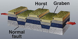
Deutsch: Diagram zur geolog. Struktur von Horsten und Graben.
|
|||
| Datum | Datum onbekend | |||
| Bron | https://earthquake.usgs.gov/learning/glossary.php?term=graben | |||
| Auteur | U.S. Geological Survey | |||
| Toestemming (Hergebruik van dit bestand) |
|
|||
| Andere versies |
Afgeleide werken van dit bestand: |

|
Bestand:Fault-Horst-Graben.svg is een vectorversie van dit bestand. Indien niet van slechtere kwaliteit dient deze gebruikt te worden in plaats van deze rasterafbeelding.
File:Horst graben.jpg → File:Fault-Horst-Graben.svg
Zie Help:SVG voor meer informatie. |
 |
Bestandsgeschiedenis
Klik op een datum/tijd om het bestand te zien zoals het destijds was.
| Datum/tijd | Miniatuur | Afmetingen | Gebruiker | Opmerking | |
|---|---|---|---|---|---|
| huidige versie | 6 dec 2008 15:29 | | 271 × 135 (41 kB) | Woudloper | {{Information |Description=Schematic cross-section through part of the upper crust under extensional tectonics where horsts and grabens formed. |Source= |Date= |Author= |Permission= |other_versions= }} {{PD-USGov-USG |
| 13 dec 2005 19:48 |  | 346 × 260 (19 kB) | Angrense | Diagram of a rift formation. Source: {{PD-USGov-Interior-USGS}} from http://earthquake.usgs.gov/image_glossary/horst.html | |
| 25 aug 2005 19:36 |  | 346 × 260 (19 kB) | Slawojar | geological structure of horst and graben {{PD-USGov-USGS}} en:Image:Horst graben.jpg Category:Geology |
Bestandsgebruik
Geen enkele pagina gebruikt dit bestand.
Globaal bestandsgebruik
De volgende andere wiki's gebruiken dit bestand:
- Gebruikt op ast.wikipedia.org
- Gebruikt op az.wikipedia.org
- Gebruikt op bg.wikipedia.org
- Gebruikt op bn.wikipedia.org
- Gebruikt op ca.wikipedia.org
- Gebruikt op da.wikipedia.org
- Gebruikt op en.wikipedia.org
- Gebruikt op en.wikibooks.org
- Gebruikt op eu.wikipedia.org
- Gebruikt op fa.wikipedia.org
- Gebruikt op fi.wikipedia.org
- Gebruikt op fr.wikipedia.org
- Gebruikt op gl.wikipedia.org
- Gebruikt op he.wikipedia.org
- Gebruikt op hy.wikipedia.org
- Gebruikt op id.wikipedia.org
- Gebruikt op it.wikipedia.org
- Gebruikt op it.wikibooks.org
- Gebruikt op it.wikiversity.org
- Gebruikt op ja.wikipedia.org
- Gebruikt op ka.wikipedia.org
- Gebruikt op kk.wikipedia.org
- Gebruikt op ko.wikipedia.org
- Gebruikt op nn.wikipedia.org
- Gebruikt op no.wikipedia.org
- Gebruikt op pl.wiktionary.org
- Gebruikt op pt.wikipedia.org
- Gebruikt op rm.wikipedia.org
- Gebruikt op ru.wikipedia.org
- Gebruikt op sk.wikipedia.org
- Gebruikt op tg.wikipedia.org
Globaal gebruik van dit bestand bekijken.