
Bestand:Rb-map.png
Rb-map.png (328 × 352 pixels, bestandsgrootte: 13 kB, MIME-type: image/png)
| Dit is een bestand van Wikimedia Commons. Onderstaande beschrijving komt van de beschrijving van het bestand daar. Controleer het gebruik van dit bestand in andere Wikimediaprojecten. |
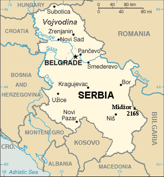
| Beschrijving | Map of the Republic of Serbia (FIPS 10 country code standard: RB) | |||
| Datum | ||||
| Bron | The World Factbook (published by CIA in 2008). | |||
| Auteur | Central Intelligence Agency of the Government of the United States of America | |||
| Toestemming (Hergebruik van dit bestand) |
|
|||
| Andere versies | Recommend that Image:Sr-map.png should be deleted and Image:Serbia-CIA WFB Map.png should be spared to show how the map looked before 2008. |
Beschrijving
Map of Serbia from The World Factbook archief kopie op de Wayback Machine (published by CIA in 2008).
This map is updated with current events; independence of Kosovo and certain faults like BUL. is replaced with BULGARIA. The name of the country is in bold font, like the name of the Autonomous Province of Vojvodina (Northern Serbian province). Also the highest mountain in Serbia (Central Serbia region) is marked at the border with Bulgaria with the name of that peak - Midžor - and added the height in meters.
The name of the file
The National Geospatial-Intelligence Agency maintains the FIPS 10 country code standard that US Government use.
On 2006-07-11 the following changes have been made:
DELETE the following geopolitical entities and codes:
- YI SERBIA AND MONTENEGRO
- YI01 Crna Gora (Montenegro)
- YI02 Srbija (Serbia)
ADD the following geopolitical entity and code:
- MJ MONTENEGRO
ADD the following geopolitical entity and code:
- RB SERBIA
The notice was issued by:
Randall E. Flynn
Geographer
National Geospatial-Intelligence Agency
GEOnet Names Server at this web-site.
Recommend that Image:Sr-map.png should be deleted and Image:Serbia-CIA WFB Map.png should be spared to show how the map looked before 2008.
Licentie
Deze afbeelding bevindt zich in het publiek domein omdat het materiaal bevat dat oorspronkelijk afkomstig is van het CIA World Factbook.
|
 |
For enhancements
| Ik, de auteursrechthebbende van dit werk, geef dit werk vrij in het publieke domein. Dit is wereldwijd van toepassing. In sommige landen is dit wettelijk niet mogelijk; in die gevallen geldt: Ik sta iedereen toe dit werk voor eender welk doel te gebruiken, zonder enige voorwaarden, tenzij zulke voorwaarden door de wet worden voorgeschreven. |
Bestandsgeschiedenis
Klik op een datum/tijd om het bestand te zien zoals het destijds was.
| Datum/tijd | Miniatuur | Afmetingen | Gebruiker | Opmerking | |
|---|---|---|---|---|---|
| huidige versie | 15 jan 2014 23:22 | | 328 × 352 (13 kB) | Denniss | Reverted to version as of 19:30, 14 February 2008 |
| 15 jan 2014 23:13 |  | 328 × 352 (36 kB) | Ivan VA | updating borders | |
| 15 jan 2014 23:12 |  | 328 × 352 (36 kB) | Ivan VA | vandalizm | |
| 3 jan 2014 00:29 |  | 328 × 352 (13 kB) | No More Cats | oops, I got the wrong version | |
| 2 jan 2014 18:11 |  | 328 × 352 (13 kB) | No More Cats | Reverted to version as of 12:25, 28 February 2011 - original CIA map | |
| 8 aug 2013 15:53 |  | 328 × 352 (36 kB) | Pokrajac | Reverted to version as of 21:00, 11 February 2011 | |
| 28 feb 2011 14:25 |  | 328 × 352 (13 kB) | IJA | Reverted to version as of 19:30, 14 February 2008 | |
| 11 feb 2011 23:00 |  | 328 × 352 (36 kB) | Pokrajac | {{Information |Description=Map of the Republic of Serbia (FIPS 10 country code standard: RB) |Source=[https://www.cia.gov/library/publications/the-world-factbook/geos/rb.html The World Factbook] (published by CIA in 2008). |Date=2008-02-28 |Author=Central | |
| 14 feb 2008 21:30 |  | 328 × 352 (13 kB) | Imbris~commonswiki | {{Information |Description=Map of the Republic of Serbia (FIPS 10 country code standard: RB) |Source=[https://www.cia.gov/library/publications/the-world-factbook/geos/rb.html The World Factbook] (published by CIA in 2008). |Date=2008-06-15 |Author=Central |
Bestandsgebruik
Dit bestand wordt op de volgende pagina gebruikt:
Globaal bestandsgebruik
De volgende andere wiki's gebruiken dit bestand:
- Gebruikt op de.wikipedia.org
- Gebruikt op eo.wikipedia.org
- Gebruikt op he.wikipedia.org
- Gebruikt op to.wikipedia.org